
CRX id
idciepochehgoboegdoonbohjgfbpamc
idciepochehgoboegdoonbohjgfbpamc
Description from extension meta
Export unexplored tiles from VeloViewer as a map overlay for Garmin devices.
Image from store
Description from store
This extension works on veloviewer.com website only.
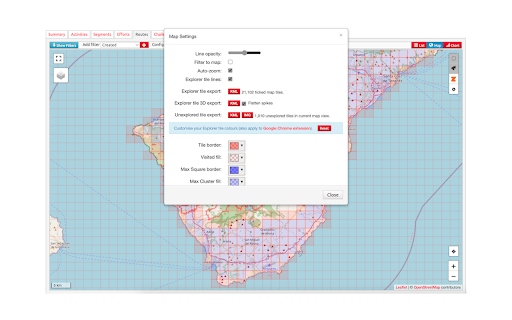
It adds an 'IMG' button to the download section on the Map Settings popup (Routes and Activities pages). Clicking the button will export all unexplored tiles in the current map view as an IMG file under the name of 'vvgmap.img'.
All you need to do next is to connect your Garmin device to the computer and put the 'vvgmap.img' file directly into the 'Garmin' folder on the device.
Next time you want to update your grid simply overwrite this file with the newly exported one. Do not upload more than one vvgmap file to your device. If you do though, still only one of them will be loaded.
A new grid layer should be visible immediately after disconnecting the device.
By default gridlines are solid, dark red and 1 pixel thick. The grid layer is visible on map scales up to 12km.
If the grid is not visible then go to Profile -> Navigation -> Map -> Map Information and click 'VVGmap unexplored tiles' to enable the map.
This extension uses an external API to generate IMG files. In case of bigger areas (thousands of tiles) it may take up to several seconds for the process to complete. During this time the 'IMG' button will remain disabled.
Latest reviews
- (2023-06-18) Richard Rutte: Works well and very easy to use. Use it on Edge 530 (also works with my old Edge 1000 explorer). Particular useful to recognise an upcoming tile-border. Tiles are best visible at lower zoom level, but that is less practical for navigation. (fiddly on 530 to change the zoom level, may be easier on devices with touchscreen). The grey line blends in with paths/streets, so less useful in urban areas.
- (2023-06-18) Richard Rutte: Works well and very easy to use. Use it on Edge 530 (also works with my old Edge 1000 explorer). Particular useful to recognise an upcoming tile-border. Tiles are best visible at lower zoom level, but that is less practical for navigation. (fiddly on 530 to change the zoom level, may be easier on devices with touchscreen). The grey line blends in with paths/streets, so less useful in urban areas.
- (2023-06-01) David Higginson: Just found this extension. Very cool - I didn't realize the Edge's had been updated to handle this sort of overlay. This was a pretty smooth process (once I found my buried USB C adapter and microUSB data cable). Next step is to see how it works on the road, but I did a quick Browse Map on my Garmin Edge 530 map and I see tiles now!
- (2023-06-01) David Higginson: Just found this extension. Very cool - I didn't realize the Edge's had been updated to handle this sort of overlay. This was a pretty smooth process (once I found my buried USB C adapter and microUSB data cable). Next step is to see how it works on the road, but I did a quick Browse Map on my Garmin Edge 530 map and I see tiles now!